
UGEOR Codes
Enables RWC's to send messages containing sunspot region data and forecasts to other RWC's and to general data users. RWC's send UGEOR messages as needed. UGEOR is issued at 0330 UT from RWC BOU.
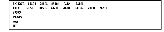
Example:
Definition of symbols:
First Line-

- UGEOR comes from GEOAlert Region summary and forecasts

- I I I I I = station indicator

- Y = last digit of year
- MM = month of year, 01 = January, 02 = February, etc
- . DD = UT day of month

- HHmm = UT hour and minute of issue
- / = filler

- dd = UT day of month of data
- / = filler
- hh = UT hour of region location

- II = starting date of forecast
- P = period (days) of forecast (usually 1 day)
- nn = number of spotted regions
- 0 = no spotted regions (SPOTNIL)
- 1 = 1 region
- 2 = 2 regions, etc.
Data Lines-

- 1 = indicates that region number for day dd follows
- RRRR = region number

- 2 = indicates that number of x-ray flares for region RRRR for day dd follows
- MM = number of class M flares
- XX = number of class X flares

- 3 = indicates that number of optical flares for region RRRR for day dd follows
- SS = number of subflares
- 1 = number of importance 1 flares
- 2 = number of flares greater than importance 1

- 4 = indicates that sunspot type for region RRRR for day dd follows
- Z = Modified Zurich classification.
- 1 = A
- 2 = B
- 3 = C
- 4 = D
- 5 = E
- 6 = F
- 7 = H
- P = Penumbra of largest spot (see Modified Zurich, "McIntosh", Sunspot Classification)
- 0 = no penumbra (x)
- 1 = rudimentary (r)
- 2 = small symmetric (s) (north to south diameter < 2.5_)
- 3 = small asymmetric (a) (north to south diameter ≥ 2.5_)
- 4 = large asymmetric (h) (north to south diameter ≥ 2.5_)
- 5 = large asymmetric (k) (north to south diameter ≥ 2.5_)
- C = Compactness of central spots
- 0 = single spot region, no compactness (x)
- 1 = open distribution (o)
- 2 = intermediate distribution (i)
- 3 = compact distribution (c)
- M = Magnetic classification
- 1 = Alpha
- 2 = Beta
- 3 = Beta-Gamma
- 4 = Gamma
- 5 = Beta/Delta
- 6 = Beta-Gamma/Delta
- 7 = Gamma/Delta

- 5 = indicates that sunspot area for region RRRR for day dd follows
- AAAA = sunspot area in millionths of the solar hemisphere
Data Lines- Continued

- 6 = indicates that total number of sunspots for region RRRR for day dd follows
- SSSS = total number of sunspots

- Q = quadrant (heliographic coordinates) of the region
- 1 = NE (northeast)
- 2 = SE (southeast)
- 3 = SW (southwest)
- 4 = NW (northwest)
- XX = distance to central meridian in degrees
- YY = heliographic latitude in degrees

- F = general forecast for region RRRR for day II
- 0 = Quiet (<50% probability of C-class flares)
- 1 = Eruptive (C-Class flares expected, probability ≥ 50%)
- 2 = Active (M-class flares expected, probability ≥ 50%)
- 3 = Major (X-class flares expected, probability ≥ 50%)
- 4 = Proton (Proton flares expected, probability ≥ 50%)
- / = No general forecast available
- C = probability of class C flares divided by ten
- 0 = 0-9%
- 1 = 10-19%
- 2 = 20-29%
- 3 = 30-39%
- 4 = 40-49%
- 5 = 50-59%
- 6 = 60-69%
- 7 = 70-79%
- 8 = 80-89%
- 9 = 90-99%
- / = No probability forecast available
- M = probability of class M flares divided by ten (see list in C flares above)
- X = probability of class X flares divided by ten (see list in C flares above)
- P = probability of Proton flares divided by ten (see list in C flares above)
Last Data Lines-

- 99999= end of data terminator; indicates that entire message has been received
Text Lines-

- PLAIN = Plain-language text information

- BT = Break in transmission (end of message terminator)
Note: / is to be used for data not available.